Early Christian ecclesiastical sites on the Dingle Peninsula
The Dingle peninsula is a landscape redolent of religious history and devotion; it is acknowledged as one the richest in archeological remains from the pre- and early Christian periods (Gallarus Oratory, Kilmalkedar and Riasc to mention a few). Díseart facilitates those seeking to understand this spiritual inheritance and those wishing to explore and research it further. We have been inspired by this legacy, as we have by the “heart for people” ethos of the Presentation community and will continue to develop programmes to enable the present generation to understand and be enriched by this heritage.Introduction
(sites and features highlighted in bold are discussed in more detail further on in the article) We do not know when the first Christians came to Ireland, but know that there was certainly a Christian community here by the early 5th century. The religion would have been brought by different missionaries working in different parts of the country (there is certainly no argument that St Patrick ever came as far south as Corca Dhuibhne!), and through contact with the Roman world. The Irish embraced the new religion in such a way that not even one martyr was ever recorded. The earliest church settlements were small communities ruled over by their own bishop, but from the mid-sixth century a monastic system became established, with an abbot at the head of each independent community, and this continued to be the norm for some centuries, even to as late, in places, as the 12th century. From the 12th century onwards we see the introduction of Continental monastic orders to Ireland, although there is no concrete evidence for any such foundation on the Dingle Peninsula, although further research might change this. Corca Dhuibhne (i.e. the Irish term for the Dingle Peninsula, taken from the name of one of the tribes who lived here in later Iron Age/Early Medieval times), though it has several monastic sites, may not have had major monasteries on the scale of Clonmacnoise or Armagh, although recent research has shown that Cill Maoilchéadair (Kilmalkedar) certainly was an important site, in some part thanks to its connection with the pilgrimage route, Cosán na Naomh. It probably rivalled in size, when at its height, some of the now better-known ecclesiastical sites elsewhere in the country, and even today one can see features associated with it spread out over a large area. In general the monastic sites on the peninsula were small, enclosed church sites, serving perhaps just the local community, with a distribution similar to that of the ringforts (enclosures within which the better-off farmers lived at this time, c. 6th-10th/11th centuries AD). The monasteries generally consist of an enclosure of earth or stone, within which can usually be found a selection of the following: church, graveyard, a tomb-shrine or leacht, ogham stone, internal dividing wall, cross-inscribed stone(s), houses and, at one or two sites, a souterrain (underground passage and chamber(s)). Holy wells are sometimes found nearby, and several sites are situated on or near Cosán na Naomh. Cill Maoilchéadair also has a sundial and a stone on which the Latin alphabet is carved. Everyday life in a monastery would have been similar to that of lay people, but with more time given to prayer and meditation, learning and teaching. The occupants were generally self-sufficient as regards food-production, farming the land immediately surrounding the monastery, which had probably been given to the monks as a gift by the local chief. Where rivers or the sea were nearby, fish would play an important part in the diet. Some industrial activity would also take place in the monastery, as happened at An Riasc. We know quite a bit about that site thanks to the excavations carried out there in the 1970s by the late Tom Fanning, under the auspices of the Office of Public Works, in whose care the site is. Gallarus is famous because of the extraordinary survival of the stone-built church there – but not everybody recognises that it is situated within a monastic site, with enclosure, cross-inscribed stone, leacht and internal dividing wall!Cill Mhaoilchéadair (Kilmalkedar)
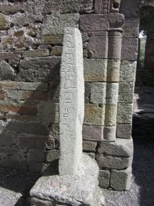
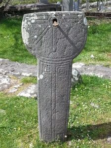
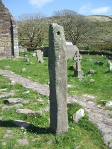
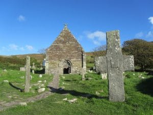
Cill Mhaoilchéadair (Kilmalkedar) was a very important monastery in the early medieval period, not least because of its situation on the pilgrimage route, Cosán na Naomh (the Saints’ Path), which continues on to Mount Brandon. Although it began life as a monastery, probably similar to that at nearby An Riasc, it became one of the wealthiest parishes in all the diocese of Kerry (then the diocese of Ardfert) in medieval times and many reminders of this wealth can still be seen there today. It was founded by St Maoilchéadair, but became associated with St Brendan, the patron saint of the diocese of Kerry, probably due to the spread of the cult of Brendan into the area around the 9th century. The 12th-century Romanesque church, probably the earliest example of this style of church in Kerry, displays fine carving, especially on the doorway and on the chancel arch. Within the graveyard are an ogham stone (5th or 6th century), a sundial (8th or 9th century – one of only 9 surviving examples in the whole country) and a large cross (possibly 12th century), as well as many other crosses. A stone known as ‘the alphabet stone’ (6th century) is to be found within the church – this amazing survival has a double inscription as well as two ornate crosses carved on it. The primary inscription is the contraction of the Latin word Domini ‘DNE’, and surrounding this are the letters of the alphabet as used at the time. Unfortunately, due to the break in the stone, the first letter is missing. Also associated with the site are St Brendan’s House (or the Priest’s House), a nearby medieval building (not currently accessible to the public), the Chancellor’s House, two holy wells, St Brendan’s Oratory (built in the style of Gallarus oratory, recently restored) and several other features in the fields roundabout. Much folklore is also associated with this site, which was in use up until very recently as the local burial ground.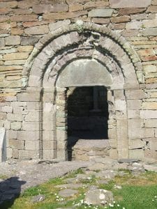
St Brendan’s Oratory
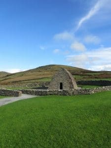
The National Monument known as ‘St Brendan’s Oratory’ is situated about 400m north-west of the core area of the site of Cill Maoilchéadair, but is certainly associated with that site, and may originally have had an enclosure wall surrounding it, as well as other features no longer visible. It is easily accessible via a small path entered by a swing gate on the road. The chapel, orientated east-west, with the (lintelled) door to the west as is usual in Christian churches, is built in a similar style to the far better-preserved church at the nearby monastic site at Gallarus, but this one no longer has its roof intact, and has also undergone some conservation works in the past, including the work completed in 2017. As with the building at Gallarus, the word ‘oratory’ is used in the literature when describing this structure; ‘oratory’ is another word for a small church. Like Gallarus, and other similar structures (e.g. as at An Raingiléis, Baile Bhoithín and Teampall Mhanacháin, An Baile Riabhach) this is a mainly dry-stone building and is built using the corbelling technique, where one stone slightly overlaps on another, as the building gets higher. Again, as at Gallarus, the stones on both the interior and exterior of the building have been worked to give a relatively smooth finish, which must have been very time-consuming for the craftsmen involved. The window ope here differs from that at Gallarus, and there is a (probably much later) stone-built altar below it, which is not a common feature at these sites in Corca Dhuibhne. It is likely that the date of this building is similar to that of Gallarus, perhaps as late as the 10th or even the 11th century, but it may be somewhat earlier.Gallarus
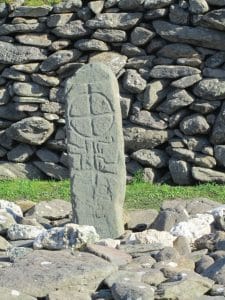
The beautiful upturned boat-shaped church at Gallarus is a mainly dry-stone building, and is the only one of its kind surviving almost completely intact on the mainland of Ireland (a gable finial is no longer in place); there are two examples on the island site of Sceilg Mhichíl, also in County Kerry (Skellig Michael, a World Heritage Site because of the surviving monastic remains), but it is not so easy to access these! The church is built using the corbelling technique, a technique also used for the construction of the many clocháin or stone round houses (also known as ‘beehive huts’ – although the roofed examples of these are usually of much later date). It is situated within a monastic enclosure, the line of which can best be seen to the back (east) of the building. The wall in front of the church divides the enclosure into the sanctuary or a sacred area (in which are the church and burial ground, marked by the cross-inscribed stone and ‘leacht’ feature) and a secular area, where, if excavation was to take place, one would expect to find the round houses and workshops of the monks. The church building is aligned east-west, with the door to the west. Inside, above the round-headed window are 3 projecting stones, which may have been used for hanging a lamp or book, or could have been for a canopy over the alter. The simple lintel-headed doorway has two holed stones projecting above it, for some form of door closure. It is impossible to accurately date this building, but modern scholars tend towards a 10th- or even 11th-century date, although others prefer to place it somewhat earlier. It would have replaced an earlier church building on the site. At the east end of the leacht is a cross, with a simple cross within a circle. An inscription on the bottom portion of the cross, which stands to the north of the church, has been read as COLUM MAC DINET; today only the COLUM is clearly visible in the bottom right-hand quadrant, but a project to make 3d images of carved stones on the peninsula (www.corcadhuibhne3d.ie) has featured this cross, and it is now once-again possible to see the inscription a bit more clearly (http://www.corcadhuibhne3d.ie/gallarus.php).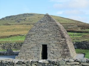
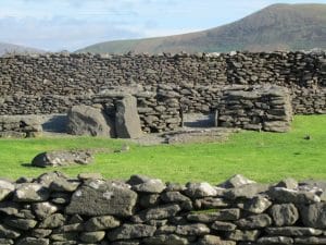
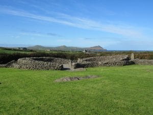
An Riasc
This early medieval monastic site was excavated during the 1970s. Before the excavation, only the beautiful cross-inscribed stone could be seen, with the road running alongside it. The road was diverted, and now the site can be seen in as much as has survived. The monastery, surrounded by an enclosure wall, contains the remains of a church, some round stone houses (clocháin), a workshop, graveyards of 2 periods, one contemporary with the monastic occupation, the other much later, and used as a cillín or children’s burial ground, probably to as late as the late nineteenth or even early twentieth century, a possible shrine and several cross-inscribed stones as well as a rectangular house which is probably of later medieval date. There is also a corn-drying kiln just outside the enclosure wall. The site was occupied probably as early as the 6th century, but it is not sure when it was finally abandoned. Artefacts found in the excavation are on display in Músaem Chorca Dhuibhne, in nearby Baile an Fheirtéaraigh (www.westkerrymuseum.com) as are some more cross-inscribed stones from the site.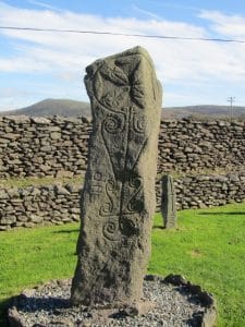
Cill na gColmán (Kilcolman), Mám an Óraigh
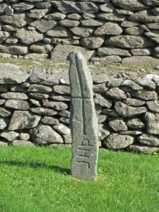
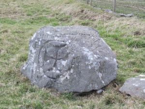
Although the monastic enclosure at Cill na gColmán, in the townland of Mám an Óraigh, near Ceann Trá, is a National Monument, the access is through private property and therefore not open to the public without first obtaining permission. This site consists of an oval enclosure within which are various features, some of which can be interpreted as the foundations of buildings, one of which might have been a small church. We know from 19th-century accounts that the site was in use as a cealluragh (or children’s) burial ground (also called a cillín, or ceallúnach) up until late in that century, but it probably began as a monastic site, similar to that at An Riasc. Perhaps the most interesting feature at this site is the ogham stone, the inscription on which has been interpreted as ‘ANM COLMAN AILITHIR’ or ‘the name of Colmán the pilgrim’. Great continuity is shown by the fact that this site, by its name, is still associated with ‘Colmán’, perhaps up to 1500 years after the inscription was carved! As well as the ogham inscription, there are two crosses on the stone, the main one of which is within a circle. Other artefacts at the site include three bullaun stones, stones with hollowed-out areas; these stones are usually only found in association with monastic sites. It is possible that this ogham stone, and indeed the whole site, were associated with the Cosán na Naomh pilgrimage route, but certainly it commemorates someone who went on pilgrimage.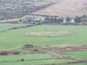
Corr Áille (Currauly)
There are many early medieval monastic sites situated throughout Corca Dhuibhne, some of which are on or near the ancient Cosán na Naomh (Saints’ Road). One of these is that at Corr Áille, which one passes on the descent from Rinn Chonaill (with Cill Mhaoilchéadair at its foot at the other side). Corr Áille is perhaps not as well-known as some of the other similar sites on the peninsula, maybe because tiredness is setting in when it is passed as you walk along the Cosán! It is not situated today in the busy part of the peninsula, most frequented by tourists, but its situation right on the path of Cosán na Naomh might indicate that it was originally established to provide shelter or other necessities to pilgrims, and would therefore have once been a very busy place. The site, similar in ways to the excavated example at An Riasc, has many of the components that one would expect to find in these monasteries. There is an enclosure, made of stone, with a clochán within it, where the occupants would have lived. There are also remains of two clocháin built into the outside (north-east) of the enclosure wall, but these presumably post-date the primary use of the site, although in one is situated the opening into a souterrain or underground passage, making it possibly as early as the 8th or 9th century AD in date. Perhaps these clocháin were for the use of pilgrims along the Cosán? Also within the site is a broken cross-inscribed stone, with a portion of it re-erected, although this has now been placed upside down! The stone had two crosses carved on it, one of which has two large spirals coming out of the top. Where the carved stone is situated appears to be a leacht, perhaps marking a special burial place, but certainly covering a burial area. There are traces of an internal dividing wall, which would have separated the sanctuary area (burial ground and perhaps a church) from the more ‘secular’ part of the site (habitation and working area). Mid-19th-century records indicate that the site was then in use as a children’s burial ground, and there are some possible grave markers from this period.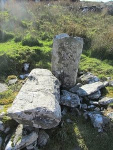
Teampall Mhanacháin, An Baile Riabhach
This monastic site, from which there is a magnificent view to the east, south and west, is one of our National Monuments and is well worth seeking out and visiting, particularly on a fine day. It is situated to the north of Ceann Trá, off the small roads between it and the Bóthar Fada from Dingle towards Baile an Fheirtéaraigh, on the lower east slopes of Leataoibh Mór. Although on private property, the landowner generously allows visitors to the site, and has even provided signs indicating where it is safe to park. A field wall follows the line of the original enclosure wall to the back of the site (uphill to north) and within the enclosure are the remains of a Gallarus-type oratory, an ogham stone, some cross-inscribed stones and also a sunken chamber/souterrain. There are also foundations that may belong to other early structures, or may be related to a later use of the site, when the population density of Corca Dhuibhne was many times higher than it is today and dwelling houses were constructed in the area. A holy well is also to be found nearby. The church survives to above lintel height, although much of it may be rebuilt, and has a shelf in the north wall. Several of the stones built into the wall of the church contain simple inscribed crosses. There are miscellaneous carved fragments within the oratory, and a finial has been restored on top of the west gable. The graveyard to the north of the church, which contains three cross-inscribed stones, was used as a children’s burial ground into the 19th century. The ogham stone, reputedly marking the grave of St Manchán, contains the inscription QENILOCI MAQI MAQI-AINIA MUC…. (Qeniloci the son of the son of Ainia, the son of….) There are also simple crosses on both faces of the stone. On Easter Sunday, at dawn (6.00 am is generally the time picked), Mass is celebrated at this site in a tradition that goes back many, many years.An Raingiléis, Baile Bhoithín
An Raingiléis – the word is often translated as ‘a ramshackle thing’, although its origins are more likely in the work eaglais (a church) – is an early monastic site situated on the Máimín, the road uphill out of Baile an Fheirtéaraigh that passes to the side of the Catholic Church, and is about 2.5km (1.5 miles) from the village. It consists of a large, almost circular stone-built enclosure (68m x 61m), which is bisected by the road. Once you pass a large stone cross (1.23m in visible height) in the field boundary to your left (i.e. the south), you know you are about to enter the site, which is one of the largest of its kind on the peninsula. The majority of the site is on the north side of the road. It probably dates from the 6th or 7th century AD but we do not know when it went out of use as a monastery. This National Monument contains within it, to the east, the ruins of a small rectangular church, which survives to roof level, although there is a lot of build-up of soil/collapse around its walls, making this difficult to see. The lintel above the doorway is, however, clearly visible. It may have originally looked like the church at Gallarus. There is also a cross-slab near the church, decorated on both faces. In front of the church is a stony mound, a leacht, which may mark the primary burial area of the monastery that was once here. In more recent centuries, the site was used as a ceallúnach, a burial ground for infants. Although excavations were carried out nearby some years ago, no excavation work has taken place within the enclosure, and there is no tradition of any particular saint being associated with it. A souterrain (underground passage) was found during the excavations (http://www.excavations.ie/report/1998/Kerry/0003443/ and see also http://www.excavations.ie/report/1999/Kerry/0004214/).Cosán na Naomh
The pilgrimage route, Cosán na Naomh (the Saints’ Path), which meanders through Corca Dhuibhne, with the summit of Mount Brandon as its goal, may well have pre-Christian origins. The pilgrimage was certainly very important from medieval times onwards, and was interlinked with the veneration of St Brendan himself. A focal point on the route was Cill Maoilchéadair (Kilmalkedar), where many of the monuments in the area commemorate St Brendan, even though the site itself was founded by St Maol Chéadair. However, there are many other monastic sites on the route of the Cosán, although some are not so well-known. These include the sites at Corr Áille and Teampall na Cluanach (in Leataoibh Mór, and on private property), and possibly also sites such as those at An Riasc, Gallarus, Cill na gColmán (Mán an Óraigh) and Teampall Mhancháin (An Baile Riabhach), most of which are discussed here. Although we have a fair idea of the route taken by the Cosán in earlier times, we cannot now be 100% certain about all of it. Today, thanks to an initiative originally of the Heritage Council, you can follow much of this path on a modern, way-marked way, beginning at Ceann Trá (Ventry) and finishing at An Baile Breac. Unfortunately a guide book to the route, published by the Council, is now out of print, but the route is marked on the OS Discover Map, No. 70, and there are information panels situated at the beginning and end of the walk. A guide leaflet can also be obtained at the Díseart, and also at Músaem Chorca Dhuibhne in Baile an Fheirtéaraigh, or you can look at it here: http://www.westkerrymuseum.com/bearla/cosan.html. It is a very popular walking route today for many, and another source for finding out about it is here: http://www.irishtrails.ie/Trail/Cosan-na-Naomh–Saints-Road-/370/). A few years ago a local man made an amazing discovery on the highest point of the route (before the ascent up Brandon itself), on the hill at Rinn Chonall, behind and to the east of Cill Mhaoilchéadair. On a rock outcrop, just to the north of the route, he saw that a spiral had been carved, at some time in antiquity. It is difficult to be sure whether this was a symbol associated with pilgrimage, or if it was something which had been carved in prehistoric times, but it was certainly a marvellous find, which has added to the already rich archaeological landscape of the area. For the past few years, on Holy Saturday, and also on a day during Heritage Week, which takes place towards the end of August, a new Pilgrim Paths initiative has taken place, where we are invited to walk one of the many pilgrim paths in the country (see www.pilgrimpath.ie); here in Corca Dhuibhne a guided walk of Cosán na Naomh as far as An Baile Breac (at the foot of Mount Brandon) has been undertaken. Mark it in your diary for next year! There is a Facebook page for the walk, at https://www.facebook.com/pages/Cos%C3%A1n-na-NaomhThe-Saints-Path/878076325550228?ref=hl (or just enter ‘Cosán na Naomh/The Saints’ Path). It will be updated intermittently during the year, but with a lot more activity in the weeks coming up to the Pilgrim Paths Walks. Do give it a ‘like’!Holy Wells
The availability of clean, pure, potable water has always been and will always be essential for all of us. Clean wells, therefore, have inevitably had an important part to play in where people settled, and some of these wells, over time, and for whatever reasons, have been attributed other benefits. With the arrival of Christianity, many of these ‘special’ wells made the transition into ‘holy’ wells, and some of these are still venerated today. There are also other ‘named’ wells, but these are not necessarily considered to be ‘holy’, as in that they are associated with a saint, or a religious site. So, how do we define a ‘holy’ well, what makes it different from all the other wells in an area? There are several reasons why a well would be considered ‘holy’ today. These include tradition, where the well has always been referred to, as long as people can remember (and going back through older written accounts), as having special powers, generally due to an association with a holy person or saint. Some wells are called after particular saints, indicating their special importance. Others may be associated with monastic or other religious sites. Some may have a cross-inscribed stone marking their location. Some have particular rituals associated with them, or ‘magical’ properties, and they may be traditionally visited on a particular holy day (the feast day of a saint, or a special day in the Christian calendar, such as Easter Sunday, for example). Some may be the focal point of a pilgrimage, or pattern. Some wells have bushes or trees nearby, on which rags or offerings are tied, indicating cures that have perhaps been obtained – or in the hope that a cure might take place! Although there are about 60 holy wells known about today in Corca Dhuibhne, not so many were still being venerated at the time that the Archaeological Survey of the area was carried out in the early 1980s, and some, by that stage, had dried up for a variety of reasons. It is interesting to note that there has been a growth of interest in the holy wells of the area since that time, which is lovely to see, as such interest helps protect these ancient sites, and ensure that their traditions survive. Some of the better-know examples on the peninsula include Tobar Manacháin at An Baile Riabhach, where the turas (or ‘pattern’, a word derived from ‘patron’, as in ‘patron saint’) takes place at dawn on Easter Sunday; Tobar Michíl, at An Baile Móir Thiar, where mass is celebrated on Michaelmas day; Tobar Ghobnait, in Ceathrú an Fheirtéaraigh in Dún Chaoin, where rounds are paid on Lá le Gobnait, 11 February, along with other practices, social and religious! Tobar Eoin Baiste, Cill Mhuire (Kilmurry), Minn Aird, and three wells in Cinn Aird (Tobar Fíonáin, Muire and Michíl) are also still venerated. There are also two holy wells, one of which is dedicated to Naomh Bhréanainn, at Cill Maoilchéadair. This is only a small sample of the many such wells on the peninsula.Ogham stones
Ogham stones are found mainly in the south of Ireland, in the counties of Kerry, Cork and Waterford, but the greatest concentration is here in Corca Dhuibhne, with over 60 known examples. They are to be found mainly in burial grounds, and are sometimes accompanied by crosses indicating Christian burial, but examples can also be found outside of these areas, and inscriptions were also sometimes carved on the much earlier (probably Bronze Age or late Neolithic) galláin or standing stones. The stones, in these cases, may have been boundary or territorial markers, or marking where someone died, or fell in battle, or indeed was buried. It is possible that some stones were associated with pilgrimage, or had other functions about which we can only guess. Some stones were taken from their original locations and re-used in the building of souterrains (underground passages sometimes associated with ringforts), or, more recently, as lintels for doors and windows of vernacular houses. The letters were carved using a grouping of between one and five notches or strokes usually on the edge of the stone, each group signifying a sound in archaic old Irish (the oldest surviving written form of the language that we have), and based on the Latin alphabet which we still use today. The inscriptions can signify a single name, or a phrase such as ‘X son of Y of the family of Z’, but sometimes a little more detail is added. The inscriptions can date from the end of the 4th up to the 8th century AD, and it is possible that inscriptions were also carved or written on other materials, organic and otherwise, which have not survived down to today. A well-known stone is that in the graveyard at Cill Mhaoilchéadair (Kilmalkedar), in front of the ruined 12th-century church there. Another can be seen at the monastic site of Teampall Mhancháin (also known as Teampall Bán), in the townland of An Baile Riabhach. Other examples are to be found in the graveyards at An Eaglais (Aglish), Cinn Aird Thoir (Kinard West, 2 stones) and Baile an Bhóthair (Ballinvoher, in An Ráth Dubh {Rathduff}, near Abhainn an Scáil, 2 stones). Collections of stones can also be found in the enclosure site at Baile an tSagairt (Ballintaggart), near Dingle race course, and in the grounds of Coláiste Íde, where stones from other places have been re-erected. These last two sites are on private property. Further information about ogham stones both on the Dingle Peninsula and elsewhere in the country can be found in the Ogham in 3d website, https://ogham.celt.dias.ie/menu.php?lang=en.The ‘Holy Stone’
Quite a bit of mystery surrounds the ‘Holy Stone’, a large boulder situated on Goat Street, Dingle, near the junction with Chapel Lane (and not to be confused with the Holyground, at the other end of town, an area possibly associated with the linen industry within the area). There are several large depressions on the upper surface of this stone, which lead archaeologists to classify it as a ‘bullaun stone’. This name, as with so many terms in Irish archaeology (gallán, clochán, leacht, crannóg, lios, rath, fulacht fiadh, tocher) comes from an Irish word, bullán/bollán, which can mean a large stone or boulder, or a hollow in a stone (depending on the dictionary you use!) These artefacts, usually seen in examples much smaller than the one in Dingle town, and generally with only one depression in them, are generally found in association with early medieval monastic sites more so than in any other context. There are several suggestions as to why the Holy Stone is where it is, and what its function may have been. It has been suggested that the stone acted as a font for the Catholic church which stood on Chapel Lane during the 18th century, and an Ordnance Survey source records that ‘rounds’ were made at it. It has also been suggested that it was once located elsewhere, at Milltown, just outside the town, where standing stones and rock art are still to be seen (which date back to the early Bronze Age, or perhaps even earlier). We will probably never know which, if any of these suggestions is the correct one. So, what were bullauns used for? Their function as holy water fonts is mentioned above, but that is in a more recent context. It has been suggested that the original purpose for these stones, particularly when found associated with early monastic sites, might be as some kind of grinding stones, but with a special ecclesiastical purpose (explaining why they are not generally found on the secular sites of the same period, i.e. the ringforts, cashels etc.) Maybe they had some form of ceremonial use, preparing materials to be used in some religious ceremonies carried out? We may never know for certain. It is interesting to note that, right beside the Holy Stone, survives one of the pumps that used supply water to the people living on the street. These items of ‘street furniture’, though of much more recent date, are as important, in a way, to the history of the town of Dingle as is the Holy Stone!Medieval parish churches
Most of the standing medieval remains on the peninsula are either the remains of parish churches, or tower-house ‘castles’ (dating from the 14th to the 16th century). It was not until the late 12th century and after that the diocesan and parochial system, on which the church in medieval and post-medieval Ireland was organised, began to fully take shape. Nineteen parishes were established in Corca Dhuibhne, with some of their churches on the sites of Early Christian establishments, although many were on new ground, and some can be associated with Anglo-Norman families which settled in the area. Today there are standing remains at 12 sites and, apart from the magnificent 12th-century Romanesque church at Kilmalkedar, they are all simple rectangular gabled buildings, with no apparent division between nave and chancel, and with little ornamentation. Among the best preserved examples are Stradbally, Killiney and Kilshannig (near Castlegregory), Ballywiheen (near Baile an Fheirtéaraigh) and Cloghane. Other churches can be seen at Dún Chaoin and Inch. Excavations in 1991 at Dún Urlann, in Na Gorta Dubha near Baile an Fheirtéaraigh, exposed the remains of the church there which had been obscured. There are grave slabs of medieval date in the cemetery around the early 19th-century St James’ Church in Dingle, which is on the site of an earlier building. At Kilmalkedar, the buildings known as ‘The Chancellor’s House’ and ‘St Brendan’s (or the Priests’) House’ might also have their origins in the later medieval period.St James’ Church and Graveyard, Dingle
The 13th-century parish church of Dingle, which was within the walled town, was dedicated to St James, and was on the site of, or close to the location of the present building there, which was built in 1807. This Church of Ireland church is perhaps better-known today as a venue for concerts during the summer months, and also the place where the Other Voices TV programmes are recorded. The stone font inside the church may have come from the earlier building. Dingle was a port from which people left for Santiago de Compostela, in Galicia in north-western Spain, on the great medieval pilgrimage in honour of St James, to whom both the medieval and later churches here were dedicated, indicating the long-standing links between this area and the Iberian Peninsula. Of interest is the graveyard surrounding the church in which are found several late medieval gravestones and tombs, as well as some cut stones from the earlier church. Four stones are of particular interest, all situated fairly centrally in the graveyard, south-south-east of the church. Easiest to locate is the stone which closes the Mullins tomb, situated just to the south of the church, beside the path that runs around it. This stone has a long inscription, in English, recording the death in 1695 of Frederick Mullins, aged 31. He was a member of the family who later lived in Burnham House, and obtained the ‘Lord Ventry’ title. Another flat stone, now broken in two, has a Latin inscription around its edge probably commemorating Gearóid FitzGerald. It is dated 1504 and bears 3 shields, one of which is the arms of the Munster FitzGeralds, in which a boar and a griffin support a saltire gules. A third stone, the trapezoidal Rice slab, is in very poor condition and the inscription, in English and Latin, is no longer legible. It commemorates Stephen Rice, who died in 1622, and his wife Ellen Trant, who died five years earlier. A shield is carved on it, with a lion rampant, although this is no longer clear. The final stone, which is wedge shaped, has no inscription, but is decorated with a swastika on one half and an interlaced curvilinear design on the other. It may well be 16th or 17th century in date. There are other, more recent, interesting grave markers in the burial ground, which has probably been the resting place of the people of Dingle since the first church was built in the 13th century and was in use right up until the 20th century.Dún Urlinn parish church, na Gorta Dubha
From the end of the 12th century, the diocesan and parochial system on which the church in medieval and post-medieval Ireland was organised began to fully take shape. Nineteen parishes were established in Corca Dhuibhne, with the diocesan capital then being situated at Ardfert. Today there are standing remains of churches at 12 of those sites and, apart from the magnificent 12th-century Romanesque church at Cill Maoilchéadair, they are all simple rectangular gabled buildings, with no apparent division between nave and chancel, and with little ornamentation. They range in date from the 12th to the 16th centuries. The church associated with the medieval parish of Dún Urlann (part of the modern parish of Baile an Fheirtéaraigh), is in na Gorta Dubha, and an extension to the medieval graveyard is still used today as the burial ground for people of the parish. Although probably established as the parish centre during the 13th century, the standing remains may date to the 15th century, having been built by the Ferriter family who held extensive lands in this area from the end of the 13th century onwards. Historical records indicate that the church was still being kept in repair into the 17th century, but was in ruin by the mid-18th century. Excavations took place at this site in 1991, under the direction of Mícheál Ó Coileáin, with the aim of exposing the remains of the church, which had become obscured. The work was carried out under the auspices of Oidhreacht Chorca Dhuibhne, and with support from the Ireland Funds. To visit the church, just walk through the modern graveyard, and you will find it down towards the back. Take note of the doorway, and also the font on the right as you enter. None of these features, or even the walls themselves, were visible prior to the excavation.Dún Chaoin medieval parish church
Very little remains to be seen above ground of the medieval parish church of Dún Chaoin, which was in existence from at least the end of the 13th century, and probably continued in use until the end of the 16th century. It is situated immediately beside the current parish church, and has been the resting place of the people of the parish from the 13th until the 20th century. Apart from a lintelled doorway in the north wall, and the remains of a rectangular window in the west wall, there are no other archaeological features of note in the building. The stone font in the porch of the modern church may have come from this building. However, this is also the resting place of Tomás Ó Criomhthain (1855-1937), an tOileánach, and his burial place is marked by a gravestone which is the work of Seamus Murphy, the famous Cork stone-carver. As well as the inscription, the decoration on the stone consists of a salmon, and a team of men rowing a canoe (although sitting the wrong way around!) Built into the outside wall of the ruined church beside the grave is an interesting depiction of the crucifix, and there are also a couple of rough stone cross grave markers in the graveyard.This page is also available in: Gaeilge (Irish)